The river Shiver-Gol. Detailed river guide. Information about river
The river Shiver-Gol (mong. Шивэр-Гол) flows in Western Mongolia, Uvs and Bayan-Olgii aimags, Eastern part of the Mongolian Altai mountains, left tributary of the river Khovd-Gol. The river lenght (with the river Irgiin-Gol) 89 km. The major tributaries: left - Khargaityn-Gol, Godzhur-Gol. The source is at foot of the peak Turgen (3965 m), the river calls Irgiin-Gol (mong. Иргийн-Гол). The river flows through the plateau Olon-Nuur, after tributary from the lake Olon-Nuur turns to south; after the confluence with the river Irgiin-Golyn-Sala calls Shiver-Gol, in the deep gorge crosses mountains range; downstream flows through semidesert plain. The river is fed by rain and melting glaciers of the mountains ranges the Turgen and the Kharkhiraa. Higest water level ussualy is in June-July.
The river can be reached by unpaved road from Olgii town via the lake Achit-Nuur and the pass Ulan-Sain-Daba (2602 m). The trip can be finished at one of the roads from Nogoonnuur (mong. Ногооннуур) to Umnegov (mong. Өмнөговь)fords.
Detailed river guide
62.8 Left tributary the Irgiin-Golyn-Salaa. The confluence can be reached by track. Sometimes here is some gers
The river valley gradually narrows, the river begins to cross the ridge. Current gradually accelerating, in the river bed continuous easy rapids. The river width 10-20 m, the islands in places. Approx. 2 km downstream the river enters the narrow (25-75 m width)gorge, continuous rapids. WW 2/2+, max. WW 3. Dominating the riverbed width is 10 m. Upstream the tributary the river a bit calms, wider. Average gradient to 55.5 km 7.40 m/km.
58.4 Left the short tributary flows from the small glacier. The river enters the gorge of 100-150 m width, with steep, canyon like slopes. The river divides to branches, continuous rapids. WW 2/2+, max. WW 3.
55.5 For a small turn to the right (around the mountain (2596.6 m height) at right bank) the river enters the narrow gorge, in places the canyon. Up to left tributary 3 difficult rapids, between them less difficult rapids. In the rapids the river narowws to 5 m. The overall section difficulty WW 5. Average gradient to tributary the Khargaityn-Gol 31.28 m/km.
54.6 Left the dry creek. Before the tributary begins long, powerful rapid, which ends approx. 50 m before the right tributary (creek). WW 5. To next rapid easier rapid.
53.6 Right the dry creek. From left also the dry creek. Is recommended to stop left before creek for scouting next rapid. The rapid begins begins immediately the tributary. In the rapid the river flows through short, canyon like crack. The leght of the rapid is approx. 100 m, the width approx. 5 m. Dowstream easier rapid approx. 150 m lenght, next difficult rapid, also in short crack. The lenght of the rapid approx. 150 m, the width 4-7 m, at the beginning of the rapid only a few meters. The rapids Grade WW 5/5+. Downstream the river easier, divides to branches in places, continuous rapids.WW 3/4. Approx. 200 m upstream the creek from left begins next difficult rapid. The lenght of the rapid approx. 250 m, the width 5-10 m. More difficult part of the rapid is approx. 50 m uppstream the creek - the river narows to a few meters. At the creek the rapid ends. WW 5/5+.
 |
 |
 |
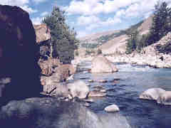
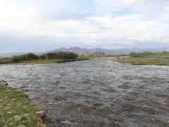
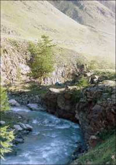
| The gorge of the Shiver-Gol | The river Khargaityn-Gol | The road ford across the Shiver-Gol (15.6 km) |
Photos are copyrighted by their owners. Author:Хосбаяр |
52.1 Left the small dry creek. 100 m downstream begins rapid, which ends 100 m downstream the right creek.
49.8 Right the small dry creek. Downstream the rapid a bit easier rapid, island in the river.
49.3 Left the small dry creek. Approx 50 m upstream the left creek begins rapid, which continues to the end of the canyon. Approx. 200 m downstream the river enters the canyon; in the canyon continuous difficult rapid. In The first third of the canyon the river a little easier, downstream very big gradient, boulders in the riverbed, high drops. The width of the river 5-10 m. WW 5/5+.
48.1 The river leaves the canyon, the rapids easier, a few islands in the riverbed. WW 3/4.
46.9 Left tributary the Khargaityn-Gol flows from glaciers of the Kharkhiraa mountains range. The river discharge increases by approx. a third. The river flows through the narrow gorge. In the river rapids, between them intervals of swift current. Dominating width of the riverbed is 10 m. WW 3/3+. Average gradient to 40.6 km 10.48 m/km.
45.8 Left dry tributary. The river character does not changes. WW 3/3+.
45.0 Left the small dry creek. The river enters the canyon. The riverbed width in the canyon 10-15 m, rapids, between them intervals of swift current. At the end of the canyon the rapid of approx. 250 m length. WW 4.
43.8 The river leaves the canyon. In places the river divides to branches, in places flows in one riverbed, valley wider. WW 2/2+.
41.4 Left tributary Goozhuur-Gol. The river divides to branches WW 2, max. 2+.
39.0 The river enters the canyon. In the canyon continuous rapids from grade WW 4 to WW 5. Rare, very short intervals of swift current. Dominating width of the river 10 m. Average gradient to 31.8 km 17.16 m/km.
32.4 Right the small dry creek. Downstream the river easier, the gradient decreases. Rapids, between them intervals of swift current. Grade approx. WW 3. The more difficult rapid (WW 4) at sharp river turn to left.
31.8 Right the dry creek. The river character does not changes. At the middle of the section the short rapid WW 4/4+. Average gradient to 25.3 km 15.85 m/km.
 |
 |
 |
| The canyon of the Shiver-Gol | The canyon of the Khargaityn-Gol | The river Khargaityn-Gol |
Photos are copyrighted by their owners. Author:Хосбаяр |
Photos are copyrighted by their owners. Author:Хосбаяр |
31.1 Right dry tributary. Valley vider, the river leaves the gorge and becomes easier. WW 2+.
30.8 Left dry tributary. In places the river divides to branches. At banks rare bushes, trees in places. WW 2/2+.
30.5 Left and right 2 dry tributaries. The river divides to branches. The current swift, easy rapids in places. At banks rare bushes. WW 2/2+.
28.6 Right dry tributary. Left mountains away from the river. The river character does not changes.
25.3 The river leaves the mountains, in places divides to branches. Swift current, easy rapids. WW 2/2+. max.WW 3-. Average gradient to road ford at 13.7 km 19.99 m/km.
18.2 The river divides to 2 main branches. Keep right. At banks bushes, trees in places. Swift current, easy rapids. WW 2/2+. A bit dowstream close to the river the narrow, not high ridge.
15.6 The ford of road from Nogoonnuur to Umnegov. A good place to finish the trip. The river divides to branches.
13.7 The ford of road from Nogoonnuur to Umnegov. A next good place to finish the trip. Average gradient to the mouth 9.45 m/km.
4.7 The confluence of both main branches.
2.0 The ford of road from Nogoonnuur to Umnegov.
0.0 The river Shiver-Gol inflows into the river Khovd-Gol (Kobdo-Gol).


